






Getting here
Walking to us from the station

These are walking routes from Folkestone Central and Folkestone West stations to our places in Folkestone and Sandgate. They are recommended in daylight only.
From Folkestone Central, the maps default goes straight along Cheriton Road. Another way in follows Cheriton Road, then Cheriton Gardens to Bouverie Square, and on along Sandgate Road, Rendezvous Street and Church Street. The longer scenic walk goes through Kingsnorth Gardens, along Castle Hill Avenue and over The Leas, then into town. From there it is a short walk down The Old High Street to the harbour. From Folkestone West the main walk starts at Station Approach and goes straight down Sandgate Hill into Sandgate, to The Ship Inn. If you have more time, there is a longer walk along The Leas and through the Lower Leas Coastal Park.
Times are Google Maps walking times, checked November 2026.
The Road of Remembrance is closed. The Leas Lift is also closed. Neither is on these walks.
Folkestone Central
This is the walk from Folkestone Central into town, to The Pullman and the other places nearby.
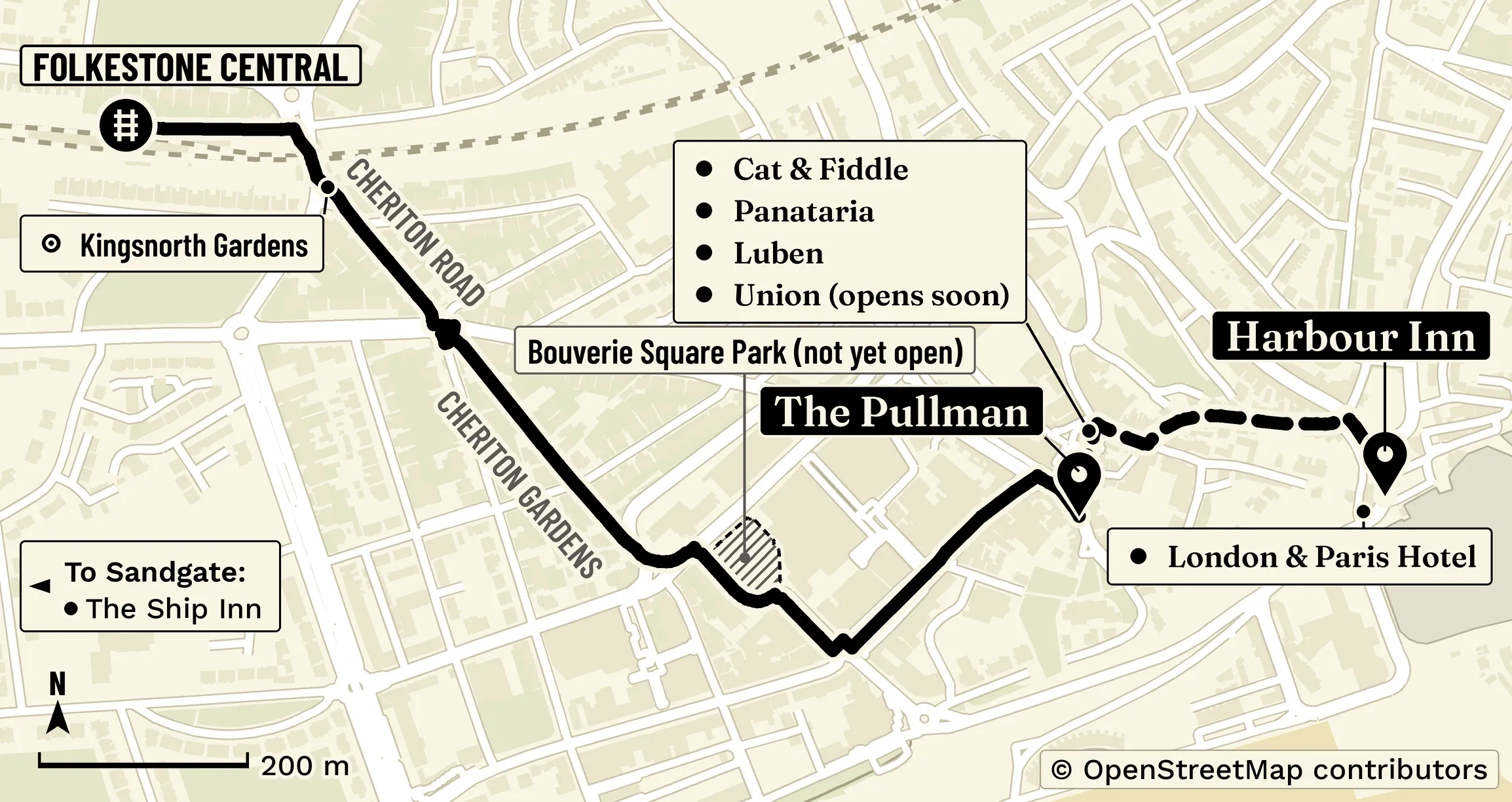
The maps default follows Cheriton Road all the way, and is the shortest walk, at about 15 minutes on Google Maps (0.7 miles), straight along Cheriton Road.
Another way in follows Cheriton Road, then Cheriton Gardens to Bouverie Square, passing south of the hoarded park site, and on along Sandgate Road, Rendezvous Street and Church Street. Cheriton Gardens is a street, not a park. That walk is about 17 minutes on Google Maps (0.8 miles).
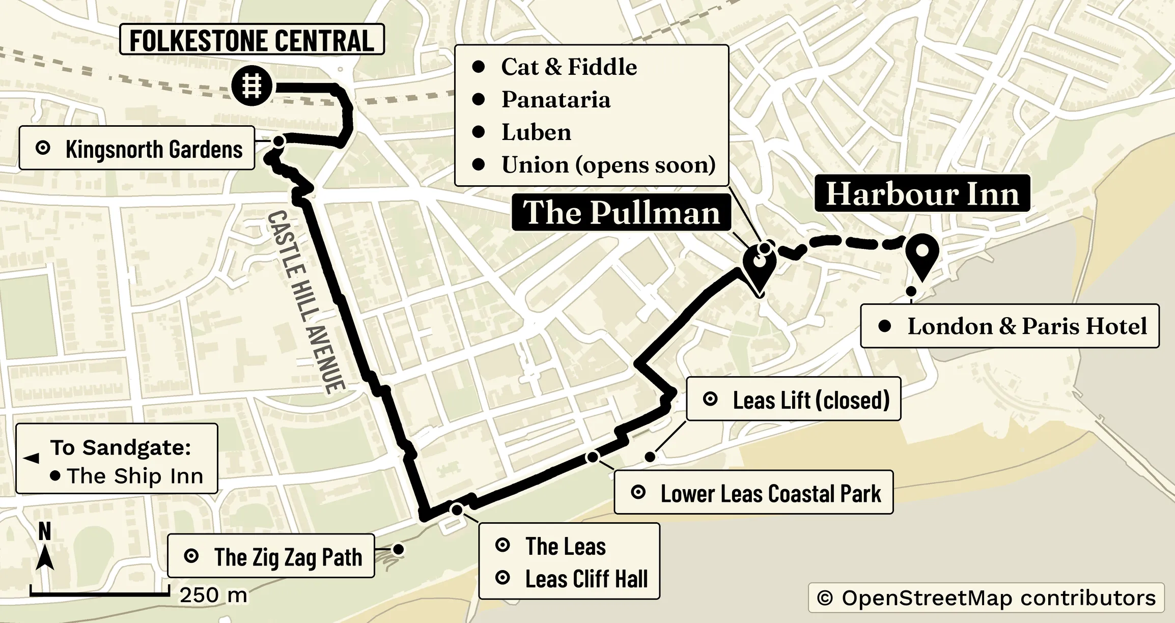
The longer scenic walk, below, goes through Kingsnorth Gardens, along Castle Hill Avenue and over The Leas, then into town. It is about 28 minutes on Google Maps (1.3 miles).
The station is on Station Approach, Folkestone CT19 5HB (National Rail). There is a step-free way out.
- Open in Google Maps, direct walk to The Pullman. Time: about 15 minutes on Google Maps (0.7 miles), via Cheriton Road.
Via Cheriton Gardens and Bouverie Square
This walk starts at Station Approach, follows Cheriton Road, crosses at the Cheriton Gardens junction, and goes along Cheriton Gardens south-east to Bouverie Square, passing south of the hoarded park site, then along Sandgate Road, Rendezvous Street and Church Street. Cheriton Gardens is a street, not a park. It is a shorter way in than the walk over The Leas.
From Folkestone Central, walk down Cheriton Road, past Kingsnorth Gardens, then along Cheriton Gardens to Bouverie Square, where a new park is being created on the former bus station site as part of Folkestone: A Brighter Future. The park is not yet open.
- Leave Folkestone Central and join Cheriton Road, heading towards town. There is a step-free way out of the station.
- Walk along Cheriton Road towards town, past Kingsnorth Gardens. You pass the gardens at the Cheriton Road entrance; this walk does not go through them.
- Cross at the Cheriton Gardens junction, then follow Cheriton Gardens south-east to Bouverie Square, passing south of the hoarded park site.
- Continue along Sandgate Road, then Rendezvous Street and Church Street.
 © OpenStreetMap contributors
- SFolkestone Central station
- 1The Pullman, Church Street (Rendezvous Street venues alongside)
- 2Harbour Inn, Harbour Street (dashed branch)
- Open in Google Maps, via Cheriton Gardens and Bouverie Square. Time: about 17 minutes (0.8 miles).
The longer scenic walk, via the gardens and The Leas
- Leave Folkestone Central by the Kingsnorth Gardens side, south of the tracks. There is a step-free way out of the station.
- Walk through or along Kingsnorth Gardens, the public garden beside the station.
- Cross to Castle Hill Avenue at the zebra crossings, then walk south along the avenue. There are zebra crossings at Kingsnorth Gardens and at Castle Hill Avenue. A tree-lined path runs along the centre of the avenue.
- At the southern end, take Langhorne Gardens onto The Leas. Visit Kent's page on The Leas is a short official introduction to the promenade.
- Walk along The Leas. You will pass Leas Cliff Hall. The Leas Bandstand sits a short way to the west if you want to see it.
- Leave The Leas by West Terrace, then continue to Sandgate Road. Do not continue towards the Road of Remembrance or the Leas Lift, which are both closed.
- Follow Sandgate Road to Rendezvous Street and Church Street.
 © OpenStreetMap contributors
- SFolkestone Central station
- 1The Pullman, Church Street (Rendezvous Street venues alongside)
- 2Harbour Inn, Harbour Street (dashed branch)
- Open in Google Maps, nicer walk to The Pullman. Time: about 28 minutes on Google Maps (1.3 miles).
Where you arrive
These places are a short walk from one another:
- The Pullman, 7 to 9 Church Street, Folkestone CT20 1SE
- Cat & Fiddle, 13 Rendezvous Street, Folkestone CT20 1EY
- Panataria, 15 Rendezvous Street, Folkestone CT20 1EY
- Luben, 24 Rendezvous Street, Folkestone CT20 1EZ
- Union, 19 to 21 Rendezvous Street, Folkestone CT20 1EY, opens soon
On to the harbour
From Church Street or Rendezvous Street, walk down The Old High Street (in the Creative Quarter) to Harbour Street. That last stretch is about 6 minutes on Google Maps (0.3 miles) from The Pullman to Harbour Inn. The Old High Street is cobbled and steep, so this harbour branch is not easy with a buggy or a wheelchair.
At the bottom you reach:
- Harbour Inn, 24 to 26 Harbour Street, Folkestone CT20 1QN
- London & Paris Hotel, 28 Harbour Street, Folkestone CT20 1QN, next door. It is adults-only.
From Harbour Inn you can walk out along the Folkestone Harbour Arm if you want to. That is an optional extra, not part of the walk from the station.
- Open in Google Maps, harbour branch. Time: about 6 minutes on Google Maps (0.3 miles), via Rendezvous Street and The Old High Street.
Steps, hills and step-free access
There is a step-free way out of Folkestone Central. The walk along Cheriton Road, Cheriton Gardens, Bouverie Square and Sandgate Road stays on the public streets. It passes south of the hoarded park site and does not go through the park, which is not yet open. The longer scenic walk stays up on The Leas and comes into town by West Terrace and Sandgate Road, so it does not use the Road of Remembrance or the Leas Lift. The Old High Street, down to the harbour, is cobbled and steep, and that branch is not easy with a buggy or a wheelchair.
Daylight
This walk is recommended in daylight only.
Folkestone West
This is the walk from Folkestone West to The Ship Inn in Sandgate. The pub is at 65 Sandgate High Street, Sandgate, Kent CT20 3AH, with the beach just across the road.
The station is on Station Approach, off Shorncliffe Road, Folkestone CT20 3PA (National Rail). Both West walks start from the Station Approach side, south of the station. There is a step-free way out.
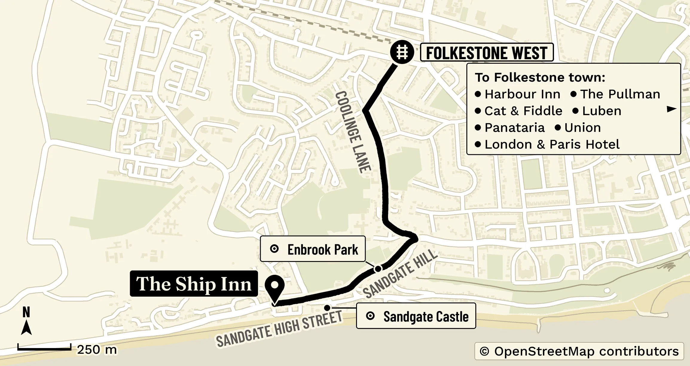
The main walk below starts at Station Approach, then goes along Shorncliffe Road and Audley Road, down Coolinge Lane, and straight down Sandgate Hill into Sandgate, to The Ship Inn. Coolinge Lane and Sandgate Hill are both steep. That walk is about 26 minutes on Google Maps (1.2 miles).
If you have more time, there is a longer walk along The Leas and through the Lower Leas Coastal Park, about 58 minutes on Google Maps (2.6 miles), via Shorncliffe Road and Earls Avenue, with about 190 feet of climbing in places. That longer walk has steps, so it is not step-free.
Main route: down Sandgate Hill into Sandgate
- Leave Folkestone West by Station Approach, on the south side of the station. There is a step-free way out of the station.
- Follow Shorncliffe Road, then Audley Road, onto Coolinge Lane. Coolinge Lane is steep.
- Continue straight down Sandgate Hill into Sandgate. Sandgate Hill is steep.
- At the bottom, join Sandgate High Street and walk to The Ship Inn at number 65.
 © OpenStreetMap contributors
- SFolkestone West station
- 1The Ship Inn, 65 Sandgate High Street, Sandgate
Where you arrive
The Ship Inn, 65 Sandgate High Street, Sandgate, Kent CT20 3AH. The beach is just across the road.
Enbrook Park is a short way north of Sandgate High Street and is open to walk through, but access may change, so check on the day.
- Open in Google Maps, main walk down Sandgate Hill. Time: about 26 minutes on Google Maps (1.2 miles). Coolinge Lane and Sandgate Hill are both steep.
If you have more time: The Leas and the Lower Leas Coastal Park
This is a longer walk, about 58 minutes on Google Maps (2.6 miles), via Shorncliffe Road and Earls Avenue, with about 190 feet of climbing in places. It is a good choice if you want more of the coast, less of a straight walk from the train. This walk has steps, so it is not step-free.
- Leave Folkestone West by Station Approach, on the south side of the station. There is a step-free way out of the station.
- Follow Shorncliffe Road (the B2064) heading east, to Earls Avenue.
- Walk south on Earls Avenue, then along Clifton Crescent, onto The Leas and to the top of the Zig Zag Path.
- Descend the Zig Zag Path into the Lower Leas Coastal Park and turn west along Lower Sandgate Road. Folkestone & Hythe District Council names this road as the way into the park. The Zig Zag Path is open.
- Continue towards Sandgate on Lower Sandgate Road and Radnor Cliff, then The Riviera and Castle Road, past Sandgate Castle, to Sandgate High Street and The Ship Inn. The steps at Radnor Cliff are open.
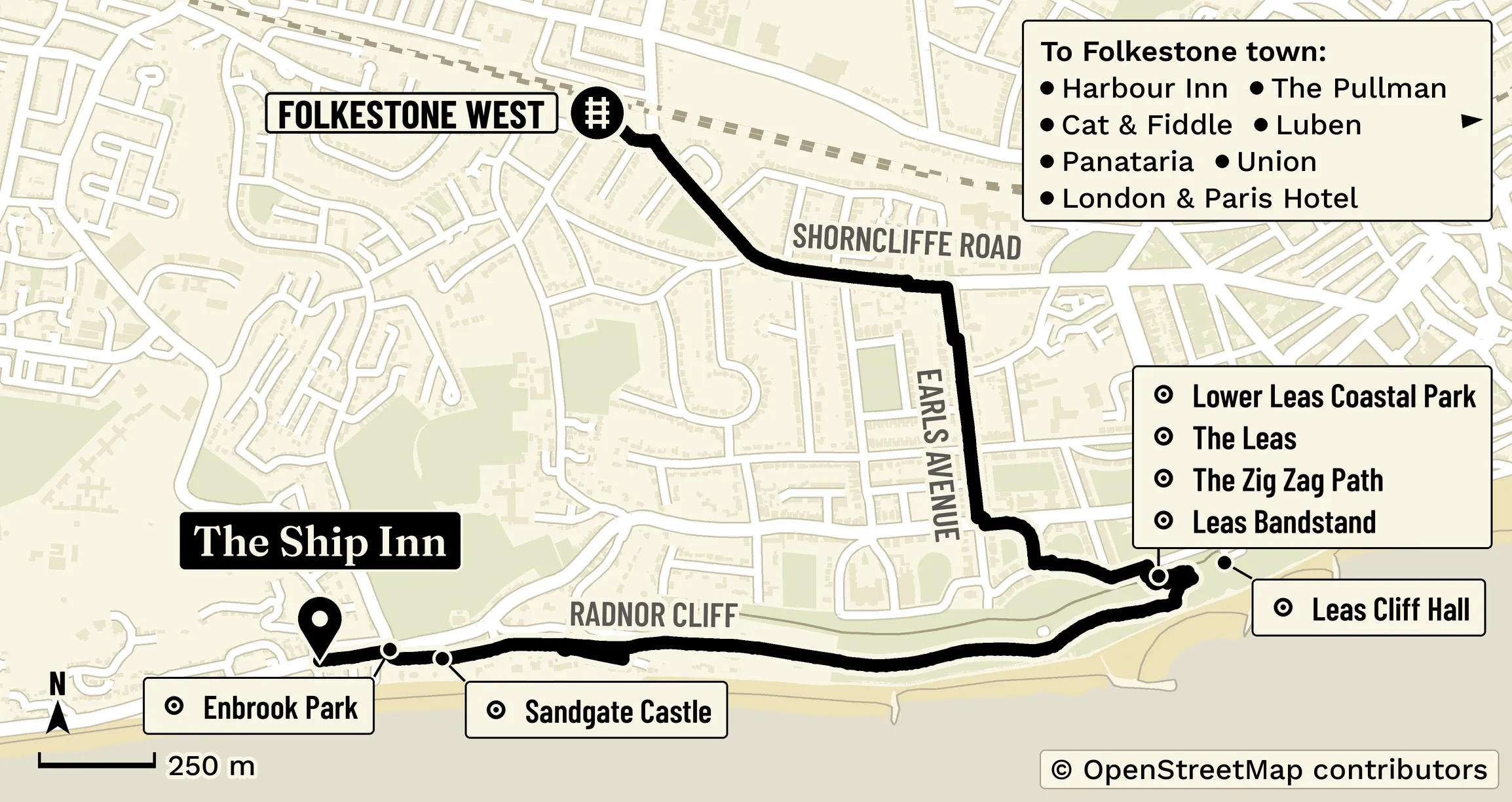 © OpenStreetMap contributors
- SFolkestone West station
- 1The Ship Inn, 65 Sandgate High Street, Sandgate
- Open in Google Maps, longer walk. Time: about 58 minutes on Google Maps (2.6 miles), via Shorncliffe Road and Earls Avenue, with about 190 feet of climbing in places.
Steps, hills and step-free access
There is a step-free way out of Folkestone West, from Station Approach on the south side of the station. Both West walks go downhill from the station to Sandgate, which sits by the sea. On the main route, Coolinge Lane and Sandgate Hill are both steep. The longer walk has steps, including the Zig Zag Path and the steps at Radnor Cliff, which are open.
Daylight
These walks are recommended in daylight only.
The Lower Leas Coastal Park has lighting and CCTV, according to Folkestone & Hythe District Council.
Read more: A nicer walk from the station in Folkestone and Sandgate
Maps: © OpenStreetMap contributors.